Nether Hub: Difference between revisions
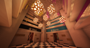
TitoSmooth (talk | contribs) (Created page with "thumb|One view of the nether hub, showcasing the K (west) and C (north) lines. thumb|Another view of the nether hub, this time displaying the C (North), M (East), and Y (South) lines. The '''Nether Hub''' is the nexus of Cobbleton's infernal transportation network. Lines extend from this central point in a hub-and-spoke design, leading outward to portals connecting to sites and settlements all over the ov...") |
TitoSmooth (talk | contribs) No edit summary |
||
| Line 2: | Line 2: | ||
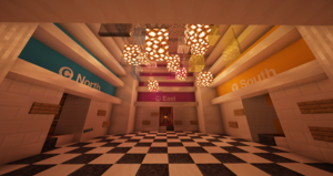
[[File:2024-06-26 22.19.49.png|thumb|Another view of the nether hub, this time displaying the C (North), M (East), and Y (South) lines.]] | [[File:2024-06-26 22.19.49.png|thumb|Another view of the nether hub, this time displaying the C (North), M (East), and Y (South) lines.]] | ||
The '''Nether Hub''' is the nexus of Cobbleton's | The '''Nether Hub''' is the nexus of Cobbleton's [[Infernal Transit Network]]. Lines extend from this central point in a hub-and-spoke design, leading outward to portals connecting to sites and settlements all over the overworld. | ||
= History = | = History = | ||
Latest revision as of 02:44, 24 November 2024


The Nether Hub is the nexus of Cobbleton's Infernal Transit Network. Lines extend from this central point in a hub-and-spoke design, leading outward to portals connecting to sites and settlements all over the overworld.
History
The Nether Hub was excavated, designed, and built by CheeseDoctor.
Connections
- C Line - Represented by the color cyan, the C line runs north from the hub to the northern boundary of the map.
- K Line - Represented by black, the K line runs west from the hub to the western boundary of the map.
- M Line - Represented by magenta, the M line runs east from the hub to the eastern boundary of the map.
- Y Line - Represented by yellow, the Y line runs south from the hub to the southern boundary of the map.
